Radar Level Sensor for River & Reservoir Monitoring: Building a Flood Early Warning System for Communities and Municipalities
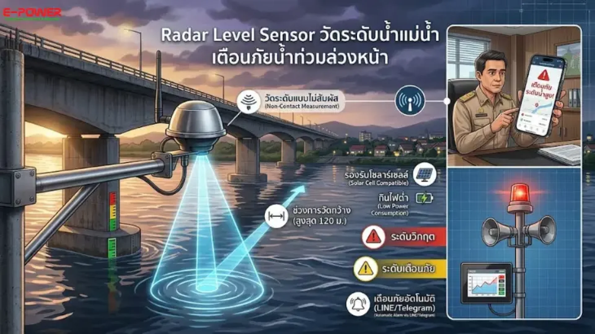
Every rainy season, flash floods and overflowing rivers put lives and property at risk. The most important question for any community is not "how do we recover?" but "how do we know in advance?" Today, the answer lies in Radar Level Sensors combined with an automated Flood Early Warning System that watches the water 24/7 — so people don't have to.
In this article, E-Power Service explains how radar level measurement works, why it has become the global standard for river and reservoir water level monitoring, and how municipalities can build a practical, affordable flood alert system.
What Is a Radar Level Sensor?
A Radar Level Sensor is a non-contact level measurement device that emits high-frequency microwave pulses (typically 26 GHz or 80 GHz) toward the water surface. By calculating the time-of-flight of the reflected signal, it determines the exact water level in real time with millimeter-level accuracy.
Because the sensor never touches the water, there is no fouling from sediment, debris, or aquatic plants — and no corrosion from wastewater or brackish water. This makes radar the most reliable and lowest-maintenance choice for outdoor hydrological monitoring.
Why Radar Is the Best Choice for Rivers and Reservoirs
Accurate in any weather — Unlike ultrasonic sensors, whose readings drift with air temperature, fog, and heavy rain, microwave radar penetrates mist and rainfall. Your flood warning system stays accurate precisely when it matters most: during a storm.
2. Non-contact, low maintenance — Mounted above the water on a bridge, pole, or bracket, radar sensors have no submerged parts to clean, unlike submersible pressure transmitters that require regular servicing.
3. Long measuring range — From a few meters up to 30–120 meters, covering everything from small canals to major rivers, dams, and large reservoirs.
4. Industry-standard outputs — 4–20 mA and RS485 Modbus RTU connect directly to PLCs, data loggers, and Cloud IoT gateways, making automated alerting straightforward.
5. Low power, solar-ready — Remote riverbank stations can run entirely on solar panels and batteries throughout the rainy season.
How a Flood Early Warning System Works
An effective community flood warning system consists of four integrated layers:
1. Sensing — Radar level sensors installed at strategic points (upstream stations, bridges, spillways, reservoir crests) measure water levels every 1–5 minutes, optionally combined with rain gauges for better flood forecasting.
2. Control — Sensor signals feed into a PLC that compares readings against three thresholds: Watch (green), Warning (yellow), and Critical (red). E-Power Service supplies Xinje and Haiwell PLCs that read 4–20 mA and Modbus RTU directly.
3. Monitoring — Live levels and historical trend graphs are displayed on an HMI touchscreen at the municipal control center, with remote access from anywhere via Haiwell Cloud HMI and Cloud Box.
4. Alerting — When a threshold is breached, the system automatically triggers sirens, warning lights, and instant LINE / Telegram notifications through the free Ecloud IoT Platform by E-Power Service — no monthly fees — while logging all data to Google Sheets for later analysis.
The result: Communities receive warnings hours — not minutes — in advance, giving residents time to move belongings, evacuate vulnerable people, and deploy pumps.
Radar vs Ultrasonic vs Pressure Sensors: A Quick Comparison
| Criteria | Radar | Ultrasonic | Submersible Pressure |
| Water contact | None | None | Fully submerged |
| Affected by rain/fog/temperature | Minimal | Significant | No |
| Fouling from debris/sediment | No | No | Yes — frequent cleaning |
| Accuracy | ±1–3 mm | ±0.25–0.5% | ±0.5% FS |
| Max range | 30–120 m | 5–15 m | Cable-length limited |
| Suitability for flood warning | ★★★★★ | ★★★ | ★★★ |
For outdoor river and reservoir monitoring that must remain dependable during the heaviest storms, radar is the clear long-term winner.
Installation Best Practices
- Mount the sensor perpendicular to the water surface, clear of the blind zone specified for each model.
- Avoid aiming at turbulent zones, standing waves, or obstacles (bridge structures, cables) within the beam angle.
- Choose upstream locations to maximize community lead time.
Use rigid mounting brackets with proper surge/lightning protection. - For off-grid sites, size the solar-plus-battery system for at least 3–5 days of autonomy.
Who Should Deploy This System?
- Municipalities and local governments — monitoring flood-prone riverside communities
- Irrigation authorities and reservoir operators — managing storage levels and discharge planning
- Industrial estates and factories — protecting production areas with advance flood barriers
- Housing projects and buildings — supervising detention ponds and drainage systems
- Farms and aquaculture — automating water level control in ponds and canals